cv | works | sculptures | site specific | environmental | land art | architectural | publications | exhibitions | symposia/lectures | cities | encounters | accounts
Dirksland Sommelsdijk & Middelharnis
|
 poplar screens at Dirksland NL |
 bridge at Dirksland NL |
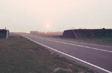 dike section Onwaardsedijk near Dirksland NL |
 convex passage at Sommelsdijk NL |
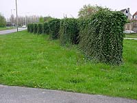 ivy noise barriers at Sommelsdijk NL |
sculptors account of the N215 project |
N215 - an artistic approach
In 1984 the ''Praktijkbureau Beeldende Kunstopdrachten'' and the Provincial
department of Construction of the province of Zuid-Holland NL (Office for Public
Art Commissions) commissioned me to make a study of the provincial plans to
project a ring-road, the S47 - now the N215 - bypassing the towns of
Middelharnis, Sommelsdijk and Dirksland in the province, South Holland. I was to
explore the possibilities for implementing innovations resulting from an
artistic perception of the plans. The Praktijkbureau was founded to explore new
possibilities for art in the public space. My involvement started out as an
experiment. After presenting my report, most of my proposals were accepted and I
was asked to join the team of the construction phase.
The area to be studied was the former island Goeree-Overflakkee, in the
south-west of The Netherlands. It is a typical Dutch polder-land - everything
made by man. For many centuries this part of Holland has been enlarged by
recapturing land from the sea and cultivated. This was a gradual change.
the road in its surroundings
Whenever a new large scale project like this one is undertaken, there is the
danger that too much of the original surroundings are lost in the attempt to fit
the new into the old situation. In this process the original infrastructure is
adapted to the direction and character of the road - drainage ditches are added
and lines of trees are planted along its axis. In this way the accent is moved
from the rural landscape to the throughway. Much damage has already been done
following this strain of thought. But this is not all - after the engineers have
gone, an even more damaging phase is provoked and eventually even encouraged -
the areas bordering the road are adapted to it and before too many years have
passed the original unity is split in half and invaded by a new entity - the
road environment.
My first proposal was to let the new road be as minimal as possible and have the
existing characteristic elements of this landscape to be left untouched and even
be restored as close to the road as was realizable. For the north section the
planning was already too far and, what I had feared, happened. The provincial
planners agreed with me and the second road-section in the Dirksland Polder was
constructed according to my proposals.
the first section
the Middelharnis entrance
My contributions to the first section of the new S47 were concentrated on the entrance to the historic towns of Middelharnis and Sommelsdijk: the Middelharnis entry used to be so that you drove straight into the town. In the new situation the new course turned to the left and you would have to take an exit to the right. That location was actually one of the most uninteresting spaces in the area. A car lot and showroom added to this. I proposed to make two earthen cones, which would function as a gateway-like entrance; their heights were to be 9.24 and 8.66 meters. Finally in 1990 the city council of Middelharnis did not want them anymore. The argumentation of the province was to no avail, and Middelharnis decided not to give permission to build any cone. The reason was that the automobile showroom would not be visible from the main road.
the Sommelsdijk entrance
The entrance to Sommelsdijk was much more subtle. The bicycle crossing cut through two convex 19 meter diameter spherical mounds in median strip. These were planned by me as an echo of the much larger cones. Now the mounds are just a reminder of what could have been. The bicycle route cuts through the mounds and is flanked by concrete walls following the convex contour. They also gave a sense of protection because of their height, which is 90cm. The noise barriers flanking the passageway into the residential area are made of wood and covered by a thick covering of ivy. They are built up of short lengths which overlap.
the second section
the road in its surroundings
The section on the other side of, the first dike, the Oudelandsedijk, was built according to my concept. Just the road was built with no extra's parallel to it. This lets one focus his attention on the passage through the second dike.
the dike - Onwaardsedijk
The second dike, the Onwaardsedijk, is a ancient and had lost its function; but because of its historical value it had been declared a monument. Its height averaged only three meters. Going over it would have changed the landscape too much because the bridge was a short distance further, and there would have been an extra perpendicular dike between the Onwaardsedijk and the dikes along the canal. So the planners had already decided to cut through it. They had planned to round off the truncated ends. This would have more or less camouflaged the dike as it was already so low. So I decided to make the cut explicit by showing it clearly. Its height and shape were presented by making a vertical cut and making it crisp with concrete walls - no higher than the dike - following its contour. One wall was black and the other white in order to further disassociate the dike from the road.
the bridge
As the planning of bridge was still in a very early stage in 1984, and my
input was still in an experimental phase, the provincial engineers proposed that
I present my ideas on it. The Dirksland Canal was a very old waterway and did
not have a straight course. Its width varied.
Because the bridge could not be too high in the landscape, the span had to be
shorter than the distance between the dikes which border the canal. A larger
span would have necessitated higher T- beams. Therefore the engineers originally
had the intention to make abutments which would project from the dikes. I did
not want obtrusive additions which did not fit in my concept of clear distinct
forms. I studied the possibilities of adapting the course of the dikes to the
unavoidable shorter span. The roads division in Brielle and I made a number of
variations which would keep the unity of the canal and its dikes and have the
bridge be no more than a plane across the water - the most elementary structure.
Once the height of the underpasses was fixed, the water level of the canal
necessitated retaining walls to keep the roads dry. That meant that an
arrangement of concrete planes was possible. In compliance with my views on the
road in the surrounding rural landscape, also here I felt the need to preserve
the character of the existing landscape and not adapt the structures of the
bridge and its retaining walls to the lines of the surroundings. Nor did I want
to change the surroundings to accommodate the bridge. So, I decided to
distinguish the structure of the bridge from its environment, and organize
elementary concrete planes in a perpendicular fashion. Each had to be an
autonomous form - a two dimensional rectangular plane. Only the dimensions and
thicknesses were variable - their juxtaposition had to be intelligible. The axis
of the Dirksland canal changes direction continuously; therefore the formation
had to be adjusted to the direction of the canal and its dikes at this location.
That meant that the road, which had its own course and was not exactly
perpendicular to the axis of the retaining walls, was to cross the bridge at a
slight angle. I decided to use color as a way of distinguishing the structure
from its surroundings. I emphasized the autonomy of each of the elements by
giving it its own color as well as differentiating the symmetric elements of the
bridge to challenge the programmed way of our interpreting that which we see.
the poplar screens
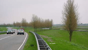
After crossing the bridge there is a large space on the right, and later on the left also; I utilized these areas to plant rows of poplar screens at a sharp angle to the road. The seven screens are only twenty five meters apart, but because they are placed at the sharp angle to the road, the actual distance one drives from one screen to the next is eighty five meters. So the rhythm one sees differs from that which he perceives. At the end of the stretch of highway, coming from the bridge, the succession of interspaces between the screens lead to a large shape -.driving from either direction, a twenty five meter square space, bounded by poplar trees, acts as a focal point. A small path winds through it; from it one finds himself in a large volume, opened to the sky. As the trees grow they at one time will form a cube (I calculate it will be around 2015).
Lucien den Arend
search this site
3D anaglyph photographs of my sculpture
works©author: Lucien den Arend
© 1998/present denarend.com
Google
this site was developed by
DutchDeltaDesign
Penttilä
Seppäläntie 860 51200 Kangasniemi Finland
telephone +358 (0)44 264 12 12
